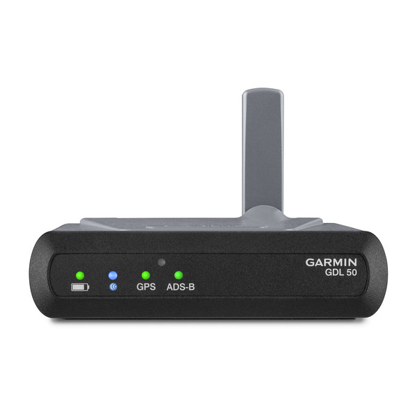
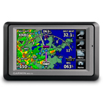
aera 550
2 Sold
-
Part Number :
- 010-00836-20
Availability: In Stock
Delivery Time : 20-25 Business Days
Key Features
With higher-resolution 9 arc-second terrain graphics, the aera 550 offers detailed aviation and automotive mapping with preloaded SafeTaxi charts and AOPA Airport Directory. Also includes built-in support for premium auto navigation and traffic features.
Aera 550 is the touchscreen aviation GPS portable that takes fingertip navigation to a whole new level. Enjoy easy transition from flying to motoring with this versatile, multi-modal navigator. Combining the best in moving-map display features with intuitive, menu-driven control, aera 550 has a crisp 4.3-inch QVGA wide-format touchscreen. Forget fiddly knobs and buttons, this flexible, feature-rich navigator provides streamlined operation for door-to-door guidance, not just runway-to-runway. Fly aera, anywhere In aviation mode, aera 550’s detailed chart-style shaded mapping and extensive terrain and aviation databases help you visualise your flight path in relation to nearby navaids, terrain, SUAs, obstructions, and so on. Plus, the inclusion of private airports and heliports in the database affords even more navigation and emergency “nearest” options. A database-driven terrain advisory feature offers TAWS-like colour coding and pop-up alerts when possible obstructions or ground proximity conflicts loom ahead. And with terrain/obstacle data shown in higher-resolution 9 arc-second detail, you’ll enjoy an enhanced level of information on the display. The unit’s graphical Terrain page offers both overhead and vertical profile views of the topography you’re flying over. What’s more, a Smart Airspace function highlights airspace at, and immediately surrounding, your current altitude. Terrain warning alarms alerts you to your surroundings and in addition to detailed flight mapping, aera 550 includes free aviation database updates for one year. GPS updating is provided at a rapid 5 Hz rate for clued-up, confident navigation. The ultimate fly-drive Enjoy full automotive GPS capability with preloaded City Navigator® NT street mapping. Inspired by Garmin’s popular nüvi® personal navigation devices, aera 550 provides voice-guided turn-by-turn directions through the built-in speaker with text-to-speech audio technology that calls out streets by name. Built-in Bluetooth® support enables wireless hands-free calling with your compatible mobile phone. Stay connected by retrieving and dialling numbers using your phone’s contact list, call history or aera’s built-in points of interest. Aera offers helpful guidance to millions of preloaded destinations including hotels, restaurants, fuel stations, cashpoints and other local attractions and, should you stray off-course, it automatically recalculates the route to get you back on track. Premium features uniquely available on aera 550 include lane assist with junction view, speed limit notification and traffic alerts¹. Aera’s single power cable streamlines the unit’s transition from cockpit to dashboard. Plus, there’s a unique ”smart mount”, which recognises the change of transport for instant clip-and-go car navigation. Garmin aera 550: the ultimate fly/drive navigator
This video(s) is for guidance and usage purposes. For actual product, kindly check details & images above.
- Part Number
- 010-00836-20
- inthebox
- aera 550
- dimensions
- 5.3"W x 3.3"H x .9"D (13.5 x 8.4 x 2.3 cm)
- DISPLAY SIZE
- 3.81"W x 2.25"H (9.7 x 5.7 cm); 4.3" diag (10.9 cm)
- DISPLAY RESOLUTION
- 480 x 272 pixels
- DISPLAY TYPE
- touchscreen WQVGA color TFT with white backlight
- Battery
- removable, rechargeable lithium-ion
- BATTERY LIFE
- up to 5 hours (less with full backlight and options)
- built in memory
- internal solid state
- accepts data cards
- yes (microSD? cards)
- waypoints favorites locations
- 3,000 (aviation mode); 1,000 (automotive mode)
- voice prompts
- yes (auto mode)
- speaks street names
- yes (auto mode)
- lane assist
- yes (auto mode)
- bluetooth wireless tech
- yes (auto mode)
- fm traffic compatible
- yes (auto mode)
- speed limit indicator
- yes (auto mode)
- custom pois
- yes (auto mode)
- preloaded street maps
- weight
- 9.5
- basemap
- routes
- 50
- ability to add maps
- waterproof
- Yes (IPX7)
- Voltage range
- 11-35
- receiver
- high-sensitivity with WAAS position accuracy
- ifr or vfr
- VFR
- navigation database
- types of jeppesen data
- full and ARTCC, FSS frequencies and final approach waypoints
- navigation database coverage areas
- Americas or Atlantic or Pacific
- movinmap
- traffic information services alerts compatible
- 3d map view
- yes (auto mode)
- preloaded terrain database
- preloaded obstacles database
- yes (U.S. and Europe only)
- preloaded safe taxi airport diagrams
- yes (U.S. only)
- preloaded aopa airport directory
- yes (U.S. only)
- preloaded low high altitude enroute airways
- preloaded private airports
- yes (U.S. only)
- patented panel page
- ifr map mode
- audible terrain alerts
- terrain resolution
- high
- smart airspace feature
- automatic logbook
- separate serial and usb interfaces
- hsi
aera 550